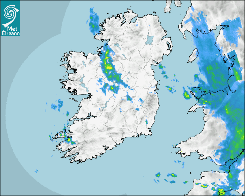

Latest Rainfall Radar showing live precipitation and the last 90 minutes precipitation over Ireland, updated every 5 minutes. Precipitation can be rain, hail or snow. Accumulations can refer to rainfall only.
Lightning strikes, when they occur, are displayed as a cross. Initially, they are red but change to orange and then yellow after a period, then disappear © Met Office ATDNet.
Ground Clutter may appear (South Co. Dublin), bright bands and spokes may also be present in images. They are artefacts (false echoes) of rainfall radar systems and should be ignored. Further information on Radar here
Met Éireann forecasters manually produce the weather icons for midday and midnight to reflect the predicted major weather type for these times.
The rainfall forecast is direct model output from Numerical Weather Prediction models but is a guideline only. Rain refers to precipitation, which can be rain, sleet or snow. It forecasts how much rain will fall (in mm) hourly during the previous hour (accumulations), then in 3 hourly and finally 6 hourly accumulations up to 7 days. This service is based on data and products of the HARMONIE-AROME and the European Centre for Medium-range Weather Forecasts (ECMWF) models.
The wind is direct model output from Numerical Weather Prediction models but is a guideline only. It forecasts the strength of the wind (in knots and km/h) at 10m for the top of each hour, in hourly, then 3 hourly and finally 6 hourly intervals up to 7 days. The wind arrow tip points in the direction the wind is blowing and the tail length indicates wind strength. However, in the text forecast below, it is described as where it is blowing from. This service is based on data and products of the HARMONIE-AROME and the European Centre for Medium-range Weather Forecasts (ECMWF) models.
The temperature is direct model output from Numerical Weather Prediction models but is a guideline only. It forecasts air temperature on land and over sea in °C for the top of each hour, 3 hourly and finally 6 hourly intervals up to 7 days. Minus zero (-0) indicates values between 0 to -0.5°C. This service is based on data and products of the HARMONIE-AROME and the European Centre for Medium-range Weather Forecasts (ECMWF) models.
The Mean Sea Level Pressure (MSLP) is direct model output from Numerical Weather Prediction models but is a guideline only. It forecasts the MSLP in hecto Pascals (hPa) for the top of that hour initially in 3 hourly intervals, then 6 hourly. This service is based on data and products of the HARMONIE-AROME and the European Centre for Medium-range Weather Forecasts (ECMWF) models.
National Forecast
22 May 2024 07:40
Today
Wednesday will bring a mix of cloud and a few sunny spells. Some early mist too. Scattered outbreaks of showery rain will occur through the day with the odd heavy burst possible. A little fresher than recent days with rather brisk northwest winds developing later. Highest temperatures of 13 to 19 degrees with best values further south.
Tonight
Tonight will turn wet and blustery across east Ulster. Drier and cloudy elsewhere with just isolated showers. Lowest temperatures of 6 to 9 degrees in moderate to fresh northwest winds.
Tomorrow
Similarly, Thursday will be dry but cloudy across much of the country. Thicker cloud across Ulster will bring some falls of rain. Cool for the time of year with highest temperatures of 11 to 15 degrees, best values across southern fringes, all in moderate to fresh northwesterly winds.
Met News

21st May 2024
Human-caused Climate Change Brings Increased Storm Rainfall
Published, May 22nd 2024 Human-induced climate cha... more

15th May 2024
We Are Recruiting for Meteorological Officers
Met Éireann, Ireland’s National Meteorological... more

02nd May 2024
Climate Statement for April 2024
Mild and wet overall April 2024 was another month ... more

01st May 2024
Government Launches Be Summer-Ready Campaign
The national ‘Be Summer-Ready’ campaign was la... more